- Prompt
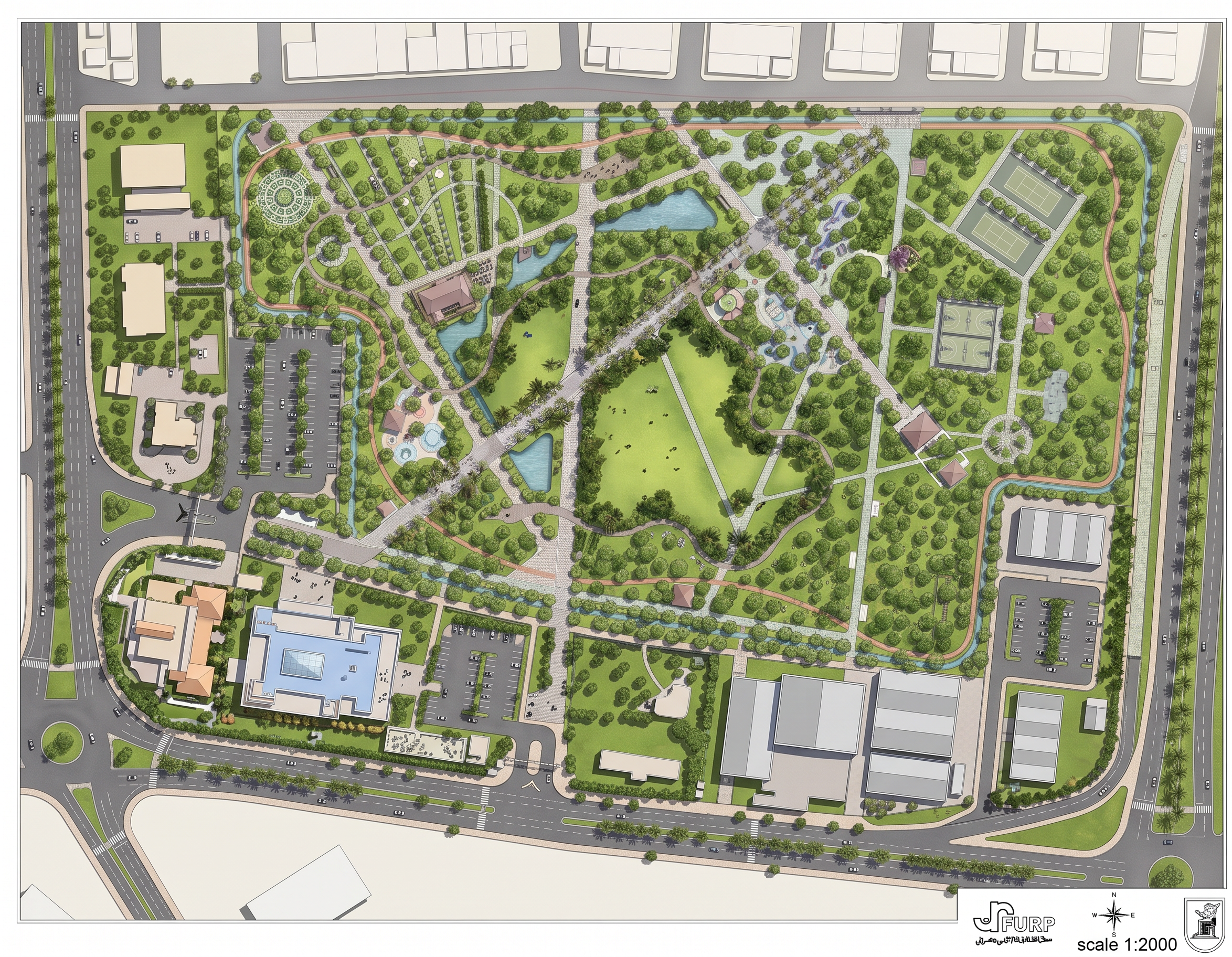
- Transform the uploaded detailed urban subdivision plan into a world-class architectural masterplan illustration while preserving the original CAD geometry with absolute precision. CRITICAL INSTRUCTION: This is NOT a conceptual redesign. This is NOT a new masterplan. This is an architectural visualization task only. Preserve every parcel boundary, road alignment, road width, block geometry, roundabout, intersection, landscape area, open space, and planning structure exactly as drawn. Do NOT merge, split, resize, rotate, relocate, remove or redesign any land parcel or road. Interpret the black-and-white subdivision drawing into a fully colored professional urban planning presentation suitable for an international planning competition, government presentation, or professional planning office. ------------------------------------------------------ LAND USE INTERPRETATION ------------------------------------------------------ Interpret the plan using the following rules: • Small repetitive parcels distributed across the entire neighborhood represent Residential plots. • The larger parcels located mainly in the middle of residential blocks represent Public Green Spaces and Neighborhood Parks. • The larger rectangular parcels aligned along the central urban axis represent Public Services including schools, healthcare facilities, community centers, administrative buildings, mosques and civic facilities. • The block located on the eastern side of the plan is the Craft / Light Industrial Zone and should contain modern workshops, light industrial buildings, service yards and organized parking. • The large roads surrounding the neighborhood are major arterial roads. • Internal streets follow a hierarchy of collector roads and local residential streets. • Central open spaces should become landscaped civic spaces connected by pedestrian movement. ------------------------------------------------------ ARCHITECTURAL STYLE ------------------------------------------------------ Create a premium architectural illustration in the style of: Sasaki AECOM Gensler SOM OMA BIG Landscape professional international urban planning competitions. Illustration style should combine: High-end architectural rendering Digital illustration Colored site plan Vector illustration Landscape rendering Professional planning graphics Competition presentation board quality NOT photorealistic satellite imagery. ------------------------------------------------------ RESIDENTIAL AREAS ------------------------------------------------------ Render all residential parcels as elegant contemporary villas and townhouse neighborhoods. Use: light beige buildings warm cream walls terracotta and light gray roofs private gardens front yards driveways boundary planting small trees shrubs community greenery while preserving every individual plot boundary exactly. ------------------------------------------------------ PUBLIC SERVICES ------------------------------------------------------ Render service parcels as contemporary civic architecture including: schools healthcare centers community centers public administration mosques social services Each building should have: public plazas drop-off areas visitor parking walking paths trees urban furniture modern landscape design. ------------------------------------------------------ GREEN SPACES ------------------------------------------------------ Transform all large central parcels into lush public parks including: large shade trees palm trees flowering trees lawns walking paths cycling paths playgrounds benches water features where appropriate pergolas lighting native planting small plazas green buffers. ------------------------------------------------------ CRAFT / LIGHT INDUSTRIAL AREA ------------------------------------------------------ Represent the eastern craft district as: modern light industrial workshops small production buildings service yards organized parking street trees loading areas clean architecture landscaped streets without heavy industry or pollution. ------------------------------------------------------ ROAD DESIGN ------------------------------------------------------ Major arterial roads: dark asphalt landscaped medians continuous palm trees traffic markings lighting Collector roads: medium asphalt street trees parking lanes wide sidewalks crosswalks Local streets: light asphalt parallel parking pedestrian-friendly environment small street trees continuous sidewalks. Roundabouts should become elegant landscaped urban nodes with signature trees and flowers. ------------------------------------------------------ PEDESTRIAN ENVIRONMENT ------------------------------------------------------ Add: people families children cyclists benches lighting crosswalks street furniture bus stops wayfinding trash bins public seating without cluttering the drawing. ------------------------------------------------------ LANDSCAPE ------------------------------------------------------ Rich Mediterranean landscape inspired by contemporary Egyptian urban developments. Mix: Royal palms Date palms Ficus Jacaranda Acacia Flower beds Native shrubs Ground cover Seasonal planting Green medians Continuous tree-lined streets. ------------------------------------------------------ COLOR PALETTE ------------------------------------------------------ Residential: Warm beige, sand, cream, terracotta roofs. Public Services: Soft blue, light gray, ivory, subtle civic colors. Green Areas: Rich natural greens with multiple shades and flowering accents. Craft Area: Neutral gray buildings with muted industrial tones. Roads: Dark asphalt with light concrete sidewalks. Parking: Light gray paving. Pedestrian paths: Natural stone paving. Urban furniture: Wood and dark steel. Landscape: Vibrant but realistic. ------------------------------------------------------ LIGHTING ------------------------------------------------------ Bright clear afternoon sunlight. Soft shadows. Warm atmosphere. Clean sky. High contrast. Excellent readability. ------------------------------------------------------ CAMERA ------------------------------------------------------ Orthographic aerial masterplan. Top-down view. No perspective distortion. Large format. Ultra high resolution. Professional presentation board. Competition quality. Every parcel line must remain readable. ------------------------------------------------------ GRAPHIC QUALITY ------------------------------------------------------ Extremely clean. Sharp edges. High-definition textures. Crisp landscape rendering. Professional architectural illustration. Balanced colors. Presentation-ready. Looks like it was produced by a leading international urban planning visualization studio. ------------------------------------------------------ FINAL PRIORITY ------------------------------------------------------ Maintain the planning geometry exactly as provided. Only add architectural character, buildings, landscape, materials, colors and urban life. The planning layout must remain identical to the uploaded drawing. The final image should look like a professionally illustrated urban masterplan prepared for an international planning competition, not an AI-generated redesign. Do not redesign the masterplan. Do not modify parcel boundaries. Do not merge parcels. Do not split parcels. Do not rotate buildings. Do not change road geometry. Do not invent new streets. Do not remove roundabouts. Do not alter block shapes. Do not change land uses. Do not replace parks with buildings. Do not place skyscrapers. Do not create futuristic architecture. Do not use satellite imagery. Do not use watercolor style. Do not blur parcel lines. Do not distort the drawing. Do not cover the plan with excessive trees. Do not hide roads. Do not simplify geometry. Do not change proportions. Do not generate perspective views. Do not crop the site. No fantasy. No sci-fi. No low resolution. No blurry rendering. No text. No labels. No legends. No redesign.
- Created
- June 26, 2026