Skip to content
Render tools
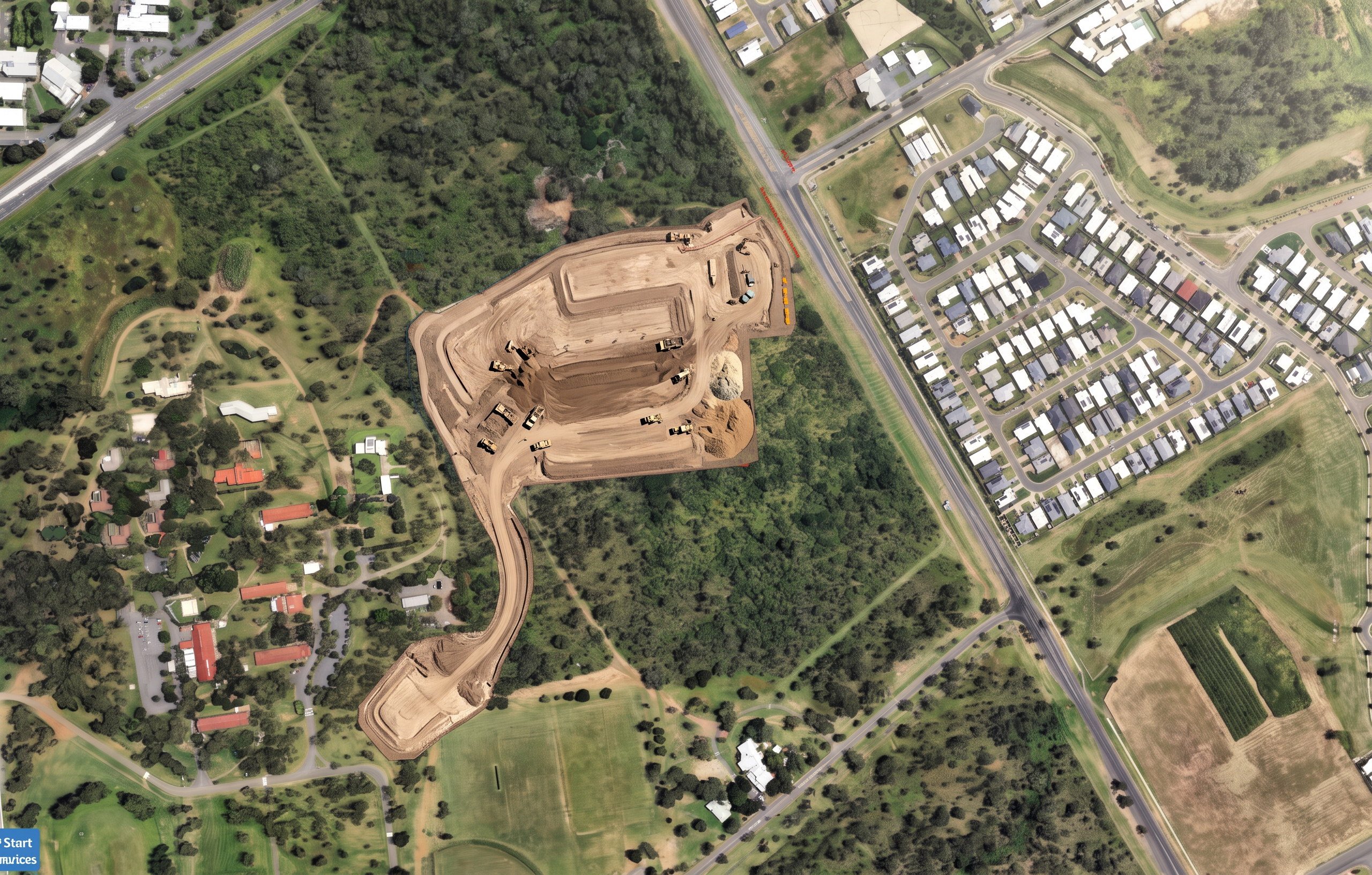
Create a photorealistic aerial construction visualisation for Rockhampton Sports Precinct – Stage 2 Bulk Earthworks.

CRITICAL INSTRUCTION

Use the supplied Overall Site image and Stage 1B Vegetation Clearing render as the reference.

Maintain the EXACT:
- camera angle
- camera position
- aerial height
- image extent
- orientation
- scale
- site coverage

The final image must appear as the same drone photograph taken several weeks later.

Do not rotate the site.

Do not crop the site.

Do not zoom in or out.

Do not alter surrounding roads, bushland or residential areas.

SITE BOUNDARY REQUIREMENTS

The brown construction footprint shown on the Overall Site image defines the EXACT approved construction area.

Treat this footprint as a hard construction boundary.

Do not alter the footprint shape.

Do not widen the footprint.

Do not create additional disturbed areas.

All construction activity must remain within the approved footprint.

Everything outside the footprint must remain unchanged.

STAGE DESCRIPTION

Vegetation clearing is substantially complete.

Bulk earthworks are now underway throughout the construction footprint.

The site is transitioning from clearing works into major earthmoving operations.

Major platforms and formation levels are beginning to take shape.

SHOW

- Bulk earthworks operations across the entire precinct.
- Cut-to-fill activities.
- Site grading underway.
- Topsoil stripping.
- Platform formation.
- Formation of future netball court areas.
- Formation of clubhouse platform.
- Formation of amenities building platform.
- Sediment basin excavation.
- Swale construction.
- Earth bund formation.
- Batter shaping.
- Temporary haul roads.
- Construction access tracks.
- Material stockpiles.
- Topsoil stockpiles.
- Excavators.
- D6/D8 dozers.
- Graders.
- Compactors.
- Rollers.
- Articulated dump trucks.
- Water cart for dust suppression.
- Survey crews working on site.
- Sediment fencing and environmental controls.

DRAINAGE CORRIDOR

The southern drainage corridor should be shaped and graded.

Show earthworks occurring within the approved corridor footprint.

Do not show courts, buildings or carparks within this area.

GROUND CONDITIONS

The site should appear approximately:

- 80% bulk earthworks complete.
- 20% earthmoving still underway.

Large areas should appear levelled and graded.

Earthworks should look engineered and organised.

VISUAL STYLE

Photorealistic drone photography.

Major regional infrastructure project.

Professional government tender visualisation.

Natural Queensland lighting.

Construction methodology storyboard image.

High detail.

Ultra realistic.

The image should clearly appear as the next construction phase immediately following vegetation clearing and immediately before underground service installation.

NO underground services.

NO trenches.

NO stormwater pipes.

NO sewer installation.

NO water services.

NO electrical conduits.

NO pit installation.

NO netball court foundations.

NO asphalt.

NO acrylic surfacing.

NO clubhouse structure.

NO amenities structure.

NO steel framing.

NO concrete slabs.

NO carparks.

NO road pavement.

NO finished infrastructure.

NO landscaping.

NO grassed areas.

NO completed works.

NO buildings.

NO construction outside the approved footprint.

DO NOT alter the site boundary.

DO NOT alter the camera angle.

DO NOT alter the site geometry.

FOOTPRINT ACCURACY IS MORE IMPORTANT THAN VISUAL REALISM.

Create renders like this

Turn any photo, sketch, or floor plan into a photoreal render in seconds.