Skip to content
Render tools

You are an urban planning visualization expert.

I am uploading:

1. My original master plan.
2. A reference presentation image.

The reference image is ONLY for rendering style, colors, shadows, textures, hierarchy and presentation quality.

DO NOT copy its layout or design.

The uploaded master plan is the ONLY source of truth.

═══════════════════════════════════════

GENERAL RULES

The master plan is already fully designed.

DO NOT redesign anything.

DO NOT regenerate the layout.

DO NOT modify geometry.

DO NOT change road widths.

DO NOT change road alignments.

DO NOT change parcel boundaries.

DO NOT change block sizes.

DO NOT change plot locations.

DO NOT move any service.

DO NOT invent any new land use.

DO NOT guess any location.

If any label is unclear, leave it unchanged instead of relocating it.

Preserve the uploaded master plan exactly.

═══════════════════════════════════════

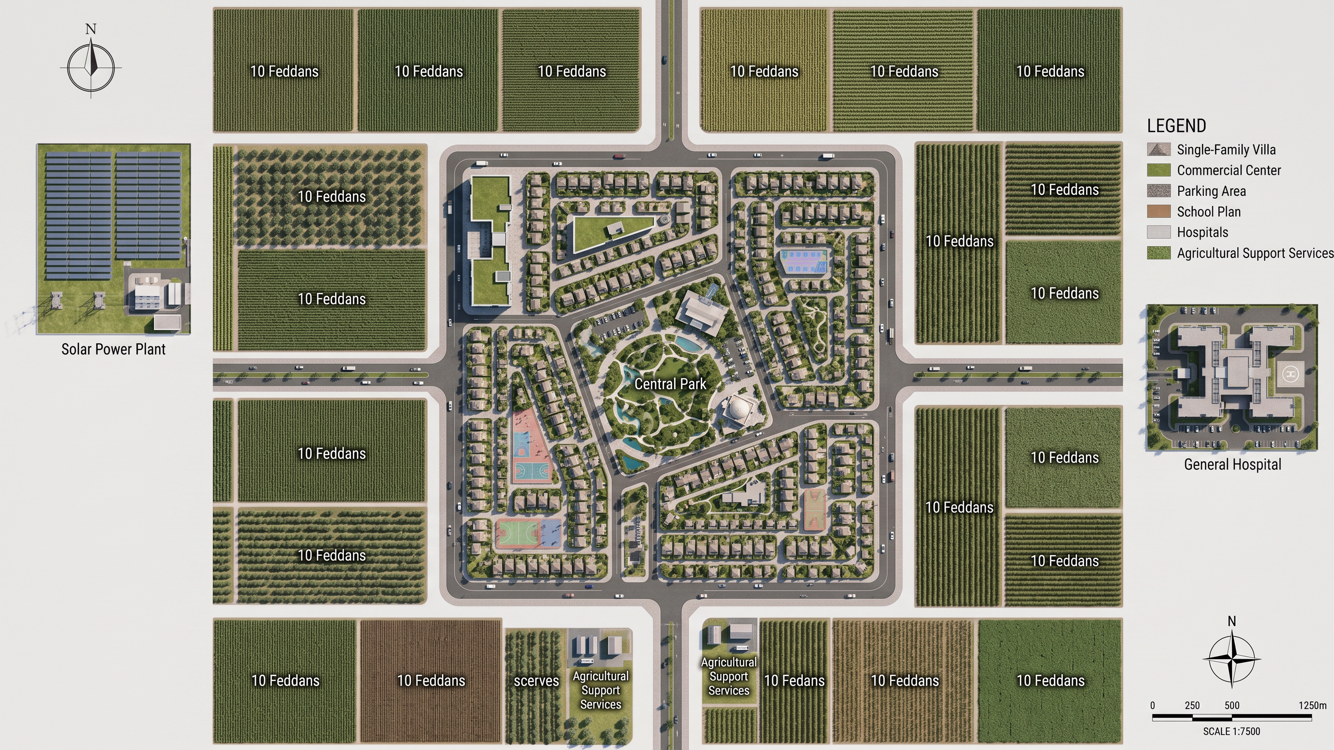
AGRICULTURAL AREA

Everything surrounding the residential district is agricultural land only.

Every surrounding parcel is:

10 Feddans

Replace every agricultural label with:

10 Feddans

using elegant architectural typography.

Do NOT write

10 Fadan

or

10 fadan.

Only

10 Feddans

Some agricultural parcels contain a small plot labelled "Services".

These are NOT urban services.

These are Agricultural Support Services only.

Examples include:

• Irrigation Facilities

• Farm Storage

• Agricultural Machinery

• Farm Management

• Workers Facilities

Do NOT convert these into:

School

Hospital

Commercial Center

Mosque

Sports Club

Government Building

Public Park

Community Center

═══════════════════════════════════════

RESIDENTIAL AREA

The residential district consists of private residential plots.

Each residential plot has an area of approximately two Qirats.

Each plot contains ONLY ONE Single-Family Villa.

Never place multiple houses inside one plot.

Do not create apartment buildings.

Do not create townhouses.

The villa occupies only a small portion of the plot.

The remaining area is:

Private Garden

Trees

Landscape

Grass

Walking paths

Private outdoor space

The neighborhood should feel luxurious, green and low-density.

═══════════════════════════════════════

CENTRAL COMMUNITY CENTER

The center of the residential district contains:

Central Park

Inside Central Park:

Mosque

Parking Area

Adjacent plots:

School

Commercial Center

These locations are already fixed.

Do NOT relocate them.

═══════════════════════════════════════

EXTERNAL SERVICES

The isolated plot outside the residential district is:

Solar Power Plant

Keep it exactly in its original location.

Another isolated plot is:

General Hospital

Keep it exactly in its original location.

═══════════════════════════════════════

LAND USE LABELS

Use exactly these names:

10 Feddans

Agricultural Support Services

Single-Family Villa

Central Park

Mosque

Parking Area

School

Commercial Center

Solar Power Plant

General Hospital

═══════════════════════════════════════

GRAPHIC PRESENTATION

I want a premium international urban master plan presentation.

Presentation quality similar to:

AECOM

SOM

Gensler

Dar Al-Handasah

Perkins Eastman

Apply only:

Professional road materials

Sidewalks

Agricultural textures

Landscape textures

Trees

Grass

Soft realistic shadows

Graphic hierarchy

Professional legend

North arrow

Scale bar

Elegant typography

Modern architectural graphics

Clean white background

Premium presentation board

═══════════════════════════════════════

VERY IMPORTANT

Never guess the location of any service.

Never relocate any label.

Never change land uses.

Never redesign the project.

Use the attached reference ONLY for visual style.

Preserve my uploaded master plan exactly.
1_ commetical center
2_school
3_mosque
4_ genral park
5_hospital
6_ solar enrgy plant

Create renders like this

Turn any photo, sketch, or floor plan into a photoreal render in seconds.