Skip to content
Render tools
Create a photorealistic aerial construction visualisation for Rockhampton Sports Precinct – Stage 1B Vegetation Clearing.

IMPORTANT:

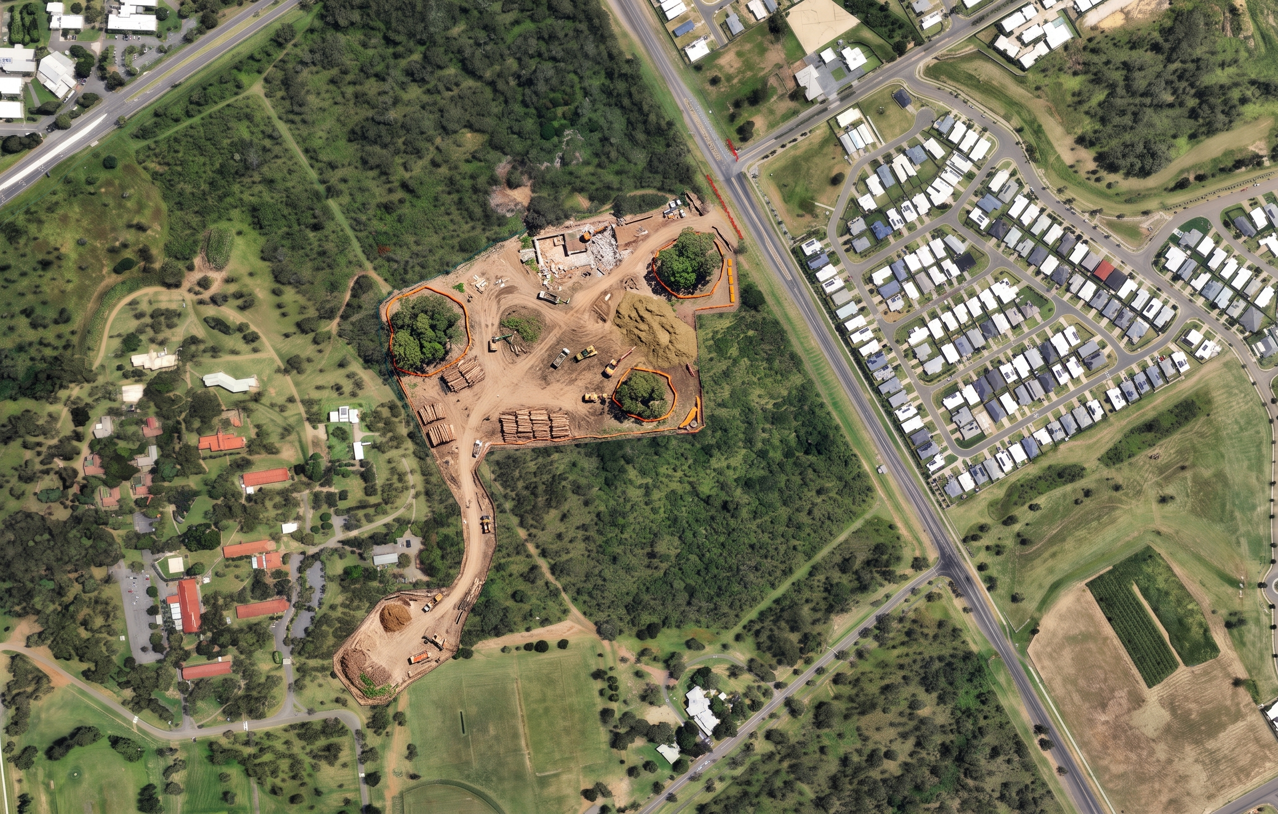
Use the supplied Overall Site image as the primary reference.

Maintain the EXACT aerial camera angle, orientation, height, zoom level, perspective, site coverage and image composition shown in the supplied aerial image.

Do not change the viewpoint.

Do not rotate the image.

Do not crop the site.

Do not zoom in.

Do not zoom out.

This image will form the first image in a construction sequencing series. Future stages will use the same perspective and camera position.

SITE ACCURACY IS CRITICAL.

The brown highlighted area shown on the Overall Site image represents the approved clearing footprint.

Only clear vegetation within the highlighted footprint.

Do not clear any vegetation outside the highlighted footprint.

Retain all surrounding vegetation, roads, residential areas and open space exactly as existing.

TREE CLEARING SEQUENCE:

Show tree clearing progressing from the southern end of the site towards the northern development pad.

The southern drainage corridor should appear furthest advanced.

The central connection corridor should be partially cleared.

The northern development area should show active clearing progressing across the footprint.

If directional clearing cannot be shown clearly, show the entire clearing footprint actively undergoing clearing operations.

SHOW:

- Selective vegetation clearing throughout the approved footprint.
- Southern drainage corridor undergoing approved clearing works.
- Tree protection fencing around retained vegetation.
- Fauna exclusion fencing installed.
- Retained vegetation clearly protected.
- Mulching operations underway.
- Timber stockpiles.
- Mulched vegetation stockpiles.
- Grubbing and stump removal activities.
- Excavators with tree grabs.
- Forestry mulchers.
- Dozers pushing cleared material.
- Tipper trucks removing cleared vegetation.
- Environmental controls and sediment fencing.
- Construction access tracks within cleared areas.

DEMOLITION ACTIVITY:

Show limited demolition activity within approved work zones.

Include:
- Demolition of existing structures.
- Removal of foundations.
- Removal of redundant services.

Show demolition only as a minor activity within the overall site.

GROUND CONDITION:

Inside the clearing footprint:
- Exposed natural earth.
- Recently cleared vegetation.
- Mulched areas.
- Cleared paths and access tracks.

Outside the clearing footprint:
- Dense existing vegetation.
- Existing bushland unchanged.
- Existing roads unchanged.
- Existing residential development unchanged.

VISUAL STYLE:

Photorealistic construction drone image.
Major infrastructure project.
Queensland native bushland setting.
Professional government tender presentation quality.
Realistic plant and equipment.
Natural lighting.
High resolution.
Ultra-detailed.
Construction methodology visualisation.
DO NOT redesign the site.

DO NOT add sports courts.

DO NOT add netball courts.

DO NOT add buildings.

DO NOT add the clubhouse.

DO NOT add the amenities building.

DO NOT add youth precinct structures.

DO NOT add carparks.

DO NOT add roads not shown in the aerial image.

DO NOT clear vegetation outside the highlighted footprint.

DO NOT change the footprint shape.

DO NOT relocate clearing areas.

DO NOT modify surrounding residential areas.

DO NOT modify surrounding roads.

DO NOT create finished construction works.

DO NOT create bulk earthworks.

DO NOT create underground services.

DO NOT create foundations.

DO NOT create asphalt surfaces.

DO NOT create landscaping.

DO NOT change the camera angle.

DO NOT change the camera height.

DO NOT crop the southern corridor.

DO NOT crop the northern development area.

DO NOT alter the scale of the image.

DO NOT invent infrastructure not shown.

Reference Priority:

1. Overall Site image (highest priority)
2. Existing aerial photography (second priority)
3. Future stage overlays (reference only for future construction sequencing)

The final render must appear as a realistic drone photograph taken immediately after mobilisation and during active vegetation clearing operations.

TREE RETENTION REQUIREMENTS:

Three existing trees/tree retention zones identified on the site plan are to remain undisturbed.

The green circular tree retention areas shown on the reference image must remain intact.

Do not remove, damage or disturb these retained trees.

Show the retained trees standing within the cleared development footprint.

Install tree protection fencing around each retained tree group.

Use highly visible temporary tree protection fencing and exclusion zones around all retained trees.

Show the retained trees as a prominent environmental protection feature within the construction site.

No plant, stockpiles, excavation or construction activities are permitted inside the tree protection zones.

Ground around retained trees to remain undisturbed.

Retained trees should contrast clearly against the surrounding cleared areas.

The three retained tree zones should be easily identifiable within the render.

Tree protection measures should appear realistic and compliant with Australian construction site standards.

Retained trees must remain healthy, established and unaffected by the surrounding clearing works.

CONSTRUCTION PROGRESSION:

Tree clearing progresses generally from south to north across the development footprint.

Southern drainage corridor clearing is most advanced.

Central corridor clearing is progressing.

Northern development footprint is actively being cleared.

The three retained tree protection zones remain untouched throughout all stages of clearing.
DO NOT remove retained trees.

DO NOT clear the three green tree retention areas.

DO NOT place stockpiles within tree protection zones.

DO NOT excavate within tree protection zones.

DO NOT place machinery within tree protection zones.

DO NOT damage retained vegetation.

DO NOT remove tree protection fencing.

DO NOT clear all vegetation within the footprint.

Tree retention areas must remain visible and intact.

Create renders like this

Turn any photo, sketch, or floor plan into a photoreal render in seconds.