- Prompt
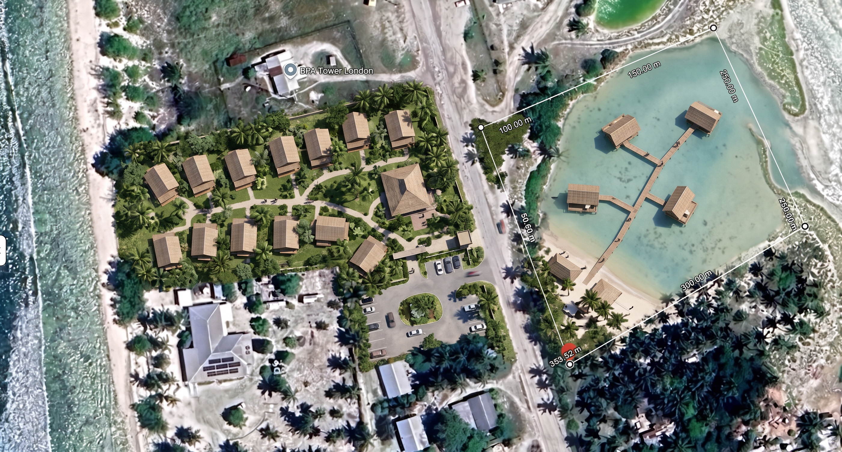
- Photorealistic 3D aerial masterplan of a low-density tropical lagoon resort in Ronton/London, Kiritimati Island, Kiribati.
Use the uploaded satellite image as the primary site reference. STRICTLY preserve the existing irregular site boundary, main public road, surrounding properties, natural lagoon edge and existing shallow water body. Do not extend development outside the site or reclaim/fill the lagoon.
Create a spacious contemporary Kiribati/Pacific tropical resort with generous natural green space, coconut palms, pandanus, coastal vegetation, shaded pedestrian paths and open lagoon views. Avoid overcrowding.
Provide:
• Maximum 15 detached single-storey tropical guest bungalows, loosely clustered and staggered for privacy and lagoon views.
• Exactly 4 small elevated lagoon huts over the retained shallow water, connected by minimal raised timber boardwalks.
• Small reception/arrival pavilion near the road.
• Small security hut and attractive entrance gateway fully INSIDE the property boundary.
• Maximum 15 landscaped car-parking spaces.
• Compact two-way driveway and internal turning circle.
• One traditional-inspired maneaba/multipurpose pavilion.
• One small open-air lagoon/beach bar.
• One sand beach-volleyball area.
• Simple landscaped pedestrian pathways.
DO NOT include a gym or water-sports cabin.
IMPORTANT: Keep the existing main public road completely unobstructed. Set the resort gate, security hut and arrival area back inside the property so no structure or vehicle blocks the road.
Preserve the existing shallow lagoon/water body as a major natural feature. No reclamation or filling. Keep most of the water open and natural, with only 4 lightweight elevated huts over it.
Use low-rise contemporary Kiribati/Pacific architecture with pitched roofs, deep overhangs, verandas, natural timber appearance and raised floors where appropriate.
Prioritise NATURAL GREEN OPEN SPACE over buildings and paving. Retain existing vegetation where possible and create generous landscape buffers and view corridors between buildings.
Render as a realistic high-resolution bird's-eye architectural masterplan showing the entire site, road, entrance, parking, 15 bungalows, maneaba, beach bar, volleyball area, retained lagoon, 4 elevated huts, boardwalks and surrounding context.
Highest priority: SITE ACCURACY, RETAIN EXISTING WATER, MAXIMUM 15 BUNGALOWS, EXACTLY 4 LAGOON HUTS, MAXIMUM 15 PARKING SPACES, MORE NATURAL OPEN GREEN SPACE, NO OVERDEVELOPMENT.
- Created
- September 20, 2026